
GNSS has been a technological breakthrough in surveying. It has transformed the precision, speed, standards and practices of surveying. It has reduced the cost, time, and errors instituting accurate geodetic networks, cadastral references and topographical information.
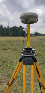
Backed by this cutting-edge technology and surveying expertise, Trimble provides surveyors with reliable GNSS survey solutions, which meets surveyor’s different requirements. Trimble R6-2 GNSS System offers advanced technology and a system design that is apt for on-site jobs. Oil and Natural Gas Corporation (ONGC) is an Indian multinational crude oil and gas corporation. ONGC has been using Trimble R6-2 model since 2010 and for an ongoing project in Cauvery Basin, Tamil Nadu it once again trusted the Trimble expertise.

The Challenge
Tough terrain is one of the biggest hurdles for field surveyors, especially in case of oil & gas company such ONGC, who do topographical surveys for 3D seismic exploration work. There are various risk involved in field survey, including physical hazards, instrument damage, and inaccurate measurements. Sometime while using RTK survey, ONGC surveyors faced problem in receiving a signal from the base — especially, when two-base with same radio frequency were used. Weather and the changing environment present another set of challenges; in case of Indian terrain heavy rainfall tops the chart. Finding a perfect working atmosphere for a surveyor is rare.
The Requirement
ONGC operations include conventional exploration and production, refining and progressive development of alternate energy sources. These mammoth projects involves a topographical survey for 3D seismic exploration work. ONGC’s project sites are spread across India including — Assam, Baroda, parts of Madhya Pradesh, Andhra Pradesh, Tamil Nadu. The project cycle is phase-wise, and each phase is intended to be completed before the monsoon season. However, given the myriad terrain and seasons in the Indian subcontinent, the aforementioned challenges requires state-of-the-art solution.
The Solution
The Cauvery Basin, Tamil Nadu project started on November 2019 and the area of the survey is about 275 sq.km. starting from Vijayawada to Kakinada. Trimble R6-2 expedited the work by automating the geocoding process for topographic maps. The in-built libraries of features and attributes made the work easier and faster. Its receiver delivered maximum accuracy and reliability with GNSS.
Trimble R-Track technology option also provided GLONASS support. GLONASS augments the GNSS signals so that a surveyor can view more satellites and measure more successfully in a tough environment. This capability powered by an innovative RTK engine made initialization faster and ONGC surveying workflow more efficient. Trimble software ensured seamless data flow and integrated surveying. It quickly transferred GNSS field data into the office for data processing. The equipment also performed well in unfavourable weather — the accuracy of collected data was unaffected and intact.
The cost-effective Trimble equipment helped to complete the project on-time, which also resulted in cutting the overhead cost.
Happy Customer
Our experience with Trimble products has been extremely satisfying. The instruments are durable that provide accurate data for high-quality deliverables. As the Trimble logo states, ‘transforming the way the world works,’ its products helped us to successfully complete our projects. Trimble executives have good knowledge of the products and techniques. They have resolved our on-site problems at the earliest. We hope that this journey and satisfying experience with Trimble is continuous.
— M. Murali, Senior Survey Officer, ONGC (Chennai), India


